Blossom Point Research Facility (BPRF) is regarded as a sub-installation of ALC. The property is located on approximately 1,600 acres of land on Cedar Point Neck in the southern part of Charles County, Maryland. It is located approximately 59 miles south of ALC and 43 miles from Washington, D.C. The installation is a military proving ground and testing facility that was established in 1942 on an isolated peninsula bounded by Nanjemoy Creek to the west and the Potomac River to the east and south.
In addition to the range operation, there is also a significant tenant presence at the Blossom Point Tracking Facility (BPTF) which is the nation’s first satellite tracking facility. The Naval Research Laboratory (NRL) established the site for the early Vanguard Project near the northeastern perimeter of BPRF in 1956. The Vanguard Project was the first solar-powered artificial satellite to be launched into orbit and is currently the oldest human-made satellite still in orbit. Today the BPTF provides command, control, communications, network engineering, and management of new and on-orbit assets.
BPRF Today/ Current Mission
Today the mission at BPRF is to support Department of Defense and Federal research programs with multi-functional test ranges.
BPRF History
BPRF is located on land originally leased from the Roman Catholic Clergymen of Maryland in 1942 by the U.S. Department of Commerce, National Bureau of Standards, Ordnance Development Division. The land had previously held multiple tenant farms operated by the Jesuits. The installation was originally named the Blossom Point Proving Ground, and it was established for the purpose of testing the experimental proximity fuzes and fuze components developed by the Ordnance Development Division, led by Harry Diamond.
The Bureau used the site until 1953, when the Ordnance Division was transferred to the U.S. Army. During this time, the Harry Diamond Ordnance Laboratory was renamed the Diamond Ordnance Fuze Laboratory (DOFL). The Blossom Point Proving Ground was also placed within the DOFL unit and continued testing fuzes and other ordnance developed by the DOFL.
Following the reorganization of the Army in 1962, the DOFL was placed under the management of the Army Materiel Command (AMC) and was renamed the Harry Diamond Laboratories (HDL). The installation was subsequently renamed the HDL Test Area.
During the Cold War era, Harry Diamond Laboratories recorded many accomplishments associated with soldier-less weaponry, primarily within the field of fuze development. State-of-the-art technologies, including air-defense missile fuzing, coded-phase fuzing, directional doppler fuzes, and M904/905 series mechanical bomb fuzes used by the Air Force, among many others, were developed and perfected at the BPRF between 1947 and 1989.
Blossom Point functioned continuously as a fuze and ordnance testing site from 1942 until 1974, when fuze testing was relocated to the Edgewood Area of the Aberdeen Proving Ground as part of a consolidation and economic move by the Army Material Command. All other testing activities ceased by 1976. In 1980, the U.S. Army purchased the property to assure its continuing ability to conduct research and testing. Blossom Point was reactivated soon after the purchase as a satellite installation of HDL. Upon its reactivation as a proving ground, Blossom Point was primarily used for field testing HDL-developed fuzes, explosive and pyrotechnic devices, and electronic telemetry systems.
BPRF Historic District
The Blossom Point Research Facility Historic District (Maryland Inventory of Historic Properties #B-1037), which was determined eligible under Criterion A for listing on the National Register of Historic Places in 2022 for its role during the Cold War as the facility at which the Army developed, tested, and perfected fuses and other military technologies between 1942 and 1989.
All the contributing buildings in the Historic District are utilitarian and designed with function in mind. They do not display any formal architectural style or features. Having been constructed during the mid-twentieth century, many of the buildings feature materials, forms, and window and door types that would have been popular during that period. However, none of the extant buildings display a distinctive Mid-Century Modern or other Modern Movement architectural style. The Historic District maintains much of its original character from the 1950s.
The Blossom Point Tracking Facility also contains buildings that are eligible for inclusion in the Blossom Point Tracking Facility Historic District.
Buildings Proposed for Removal at Blossom Point Research Facility
Buildings 202, 203, 513 and 514 at USAG APG ALC BPRF are no longer needed for the testing mission and are proposed for demolition as there is no alternative use for the buildings now or in the foreseeable future.
Since these buildings are part of the BPRF Historic District, the USAG APG is providing information on the history and use of each building to mitigate the adverse effect the removal would have on the Historic District. A majority of the original buildings from the 1950s remain and are in use today.
The buildings proposed for removal include:
·Building 202, also known as the Wet/Cold Room, was built in 1942, and is MIHP # CH-1037-2. It is a small, one-story, two-bay-wide building resting on concrete foundation, clad in standing-seam metal, and capped with a standing-seam metal side gable roof, measuring 120 square feet. This building was moved away from the ranges from its original location.
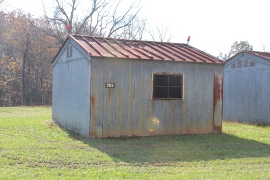
Building 203, Wet/Cold Room, built 1942, Contributing, and is MIHP # CH-1037-3.
It is a small, one-story, two-bay-wide building resting on concrete foundation, clad in standing-seam metal, and capped with a standing-seam metal side gable roof, measuring 120 square feet. This building was moved away from the ranges from its original location.

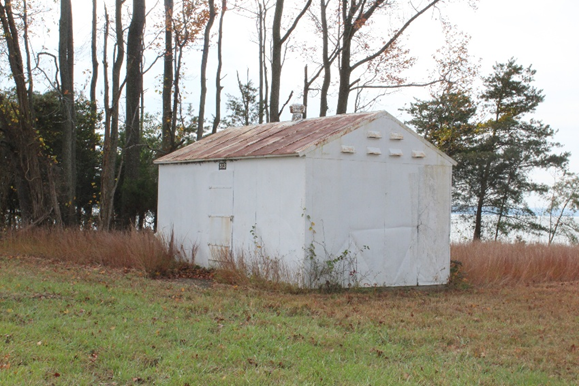
·Building 513, Ordnance Facility, built 1951, Contributing, and is MIHP # CH-1037-19. It is a small, one-story, one-bay-wide, rectangular building resting on a poured concrete foundation, clad in metal panels, and capped with a standing-seam metal side gable roof, measuring 224 square feet.
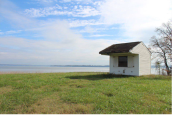
Building 514, Camera House, built 1951, Contributing, and is MIHP # CH-1037-20. It is a small, one-story, one-bay-wide, wood-frame building resting on a concrete foundation, clad in vinyl siding, and capped with a side gable roof with a deep overhanging canopy sheltering a large, fixed observation window on the façade, measuring 132 square feet. This building was moved from its original location.