


Follow our social media channels and My Army Post App as we continue with around the clock updates to keep you informed and safe
The 2026 Atlantic Hurricane Season is here, and forecasts call for another above average season. The time to prepare is now and the DPTMS Protection Team is available to conduct information briefs to units, Soldiers and Soldier/Family Readiness Groups and Command Steering Committee Meetings. Most of all we need to educate our Spouses on preparations and evacuation measures should it be needed. Please contact 571-801-2038 to request a briefing.
NOAA Map


HURRICANE

The 2026 Atlantic Hurricane Season is here, and forecasts call for another above average season. The time to prepare is now and the DPTMS Protection Team is available to conduct information briefs to units, Soldiers and Soldier/Family Readiness Groups and Command Steering Committee Meetings. Most of all we need to educate our Spouses on preparations and evacuation measures should it be needed. Please contact 571-801-2038 to request a briefing.
Atlantic Seasonal Hurricane Activity
Colorado State University will release its 2026 Atlantic hurricane season forecast on April 9, 2026, providing projections for named storms, hurricanes, and major hurricanes, influenced by El Niño and other climate factors.
Forecast for 2026 Hurricane Activity
Forecast Parameters | CSU Forecast for 2026* | Average for 1991-2020 |
Named Storms | 13 | 14.4 |
Named Storm Days | 55 | 69.4 |
Hurricanes | 6 | 7.2 |
Hurricane Days | 20 | 27.0 |
Major Hurricanes | 2 | 3.2 |
Major Hurricane Days | 5 | 7.4 |
Accumulated Cyclone Energy (ACE)+ | 90 | 123 |
ACE West of 60 degrees longitude | 50 | 73 |
*CSU's initial seasonal forecast for 2026 was released on Thursday, April 9th. | ||
+A measure of a named storm's potential for wind and storm surge destruction defined as the sum of the square of a named storm's maximum wind speed (in 104 knots2) for each 6-hour period of its existence. | ||
2026 Forecast Summary
CSU anticipate that the 2026 Atlantic basin hurricane season will have somewhat below-normal activity. Current weak La Niña conditions are likely to transition to El Niño in the next few months, with the potential for a moderate/strong El Niño for the peak of hurricane season. Sea surface temperatures in the western tropical Atlantic are warmer than normal but slightly cooler than normal in the eastern and central tropical Atlantic. CSU anticipate El Niño being the dominant factor for the upcoming hurricane season, driving increased levels of tropical Atlantic vertical wind shear. They are forecasting a below-average probability for major hurricane landfalls along the continental United States coastline and in the Caribbean. As with all hurricane seasons, coastal residents are reminded that it only takes one hurricane making landfall to make it an active season. Thorough preparations should be made every season, regardless of predicted activity.
Saffir-Simpson Hurricane Wind Scale
Tropical Weather Track
National Hurricane Center - Miami, FL.
Closing Tab
WINTER STORMS

Winter Weather
While the danger from winter weather varies across the state, most Georgians are likely to face some type of severe winter weather at some point in their lives. That could mean snow or subfreezing temperatures, as well as strong winds or even ice or heavy rainstorms. Winter storms can result in extreme cold, downed power lines and blocked roads and highways.
Before Winter Weather
A storm can occur when family members are in different places, so develop a family communications plan.
- Make a Ready kit for at least three days of self-sufficiency.
- Familiarize yourself with the terms that are used to identify winter weather.
- Keep space heater safety in mind: Use electric space heaters with automatic shut-off switches and non-glowing elements. Remember to keep all heat sources at least three feet away from furniture and drapes.
Prepare your home:
- Make sure your home is well insulated and that you have weather stripping around your doors and window sills to keep the warm air inside.
- Make sure you have a working carbon monoxide detector.
- If you have a wood burning fireplace, consider storing wood to keep you warm if winter weather knocks out your heat. Also, make sure you have your chimney cleaned and inspected every year.
- Have at least one of the following heat sources in case the power goes out:
- Extra blankets, sleeping bags and warm winter coats
- Fireplace or wood-burning stove with plenty of dry firewood, or a gas log fireplace
- Kerosene heater, with proper ventilation.
Prepare your vehicle:
- Fully winterize your vehicle: Have a mechanic check antifreeze, brakes, heater and defroster, tires, and windshield wipers to ensure they are in good shape. Keep your gas tank at least half full.
- Keep an extra Ready kit in the trunk of your car. In addition to the basic essentials, consider adding a portable cell phone charger, ice scraper, extra blanket, sand for traction and jumper cables.
- Make sure you have a cell phone with an emergency charging option (car, solar, hand crank, etc.) in case of a power failure.
- People who depend on electricity to operate medical equipment should have alternate arrangements in place in case power is out for an extended period of time.
- Plan to check on elderly/disabled relatives and neighbors.
- Plan to bring Pets inside.
- Know where the manual release lever of your electric garage door opener is located and how to operate it in case you lose power.
- Fill a gallon container with water and place them in the freezer to help keep food cold.
During Winter Weather:
- Listen to NOAA Weather Radio to stay informed of winter weather watches and warnings. Also monitor commercial radio, television, and the Internet.
- Check on elderly/disabled relatives and neighbors.
- Bring pets inside.
- Keep in mind that during a severe winter storm it could be hours, or even days, before emergency personnel are able to reach you. Don’t call 911 for information or to report a power outage.
- Allow faucets to drip a little during cold weather to avoid freezing.
- Open cabinet doors to allow heat to get to un-insulated pipes under sinks and appliances near exterior walls.
- Winter storms are often accompanied by power outages. Always exercise caution when using alternative light and heating sources:
- Use flashlights during power outages instead of candles to prevent the risk of fire, and have plenty of extra batteries on-hand.
- Never use an oven to heat your home. Never bring portable generators, camp stoves and grills into your home; they should only be used outside. Keep them at least 20 feet away from your home’s windows, doors and vents to prevent deadly carbon monoxide poisoning.
- Use flashlights during power outages instead of candles to prevent the risk of fire, and have plenty of extra batteries on-hand.
- Follow tips for keeping food safe in an emergency.
- Watch for frostbite. Warning signs include white or grayish-yellow skin, numbness and skin that feels unusually firm or waxy. If symptoms are detected, get medical help immediately. If medical help is not available, get the victim to a warm location and immerse the affected area in warm water. Frostbitten areas are numb and can be easily burned so avoid using heating pads, fireplaces or radiators for warming. Do not rub the frostbitten area; this could cause more damage.
- Watch for signs of hypothermia, including shivering, memory loss, fumbling hands, slurred speech and drowsiness. If the victim’s body temperature is below 95 degrees, seek medical help immediately. If medical help is not available, get the victim to a warm location, remove wet clothing, warm the center of the body first using an electric blanket and if conscious, give the victim warm, non-alcoholic beverages.
- Follow directions from local officials about driving during snow and ice storms, and drive with caution.
Winter Weather Driving :
Minimize travel during winter weather. If you can postpone your trip or if it is non-essential, stay in when the weather is really bad. If you don’t have somewhere you have to be, watch the snow from indoors.
Learn more about winter weather driving…
Winter Weather Terms:
Knowing winter weather terms helps you know when to put your personal preparedness plan into action. There are three key winter weather terms to know: winter storm watch, winter storm advisory and winter storm warning.
Learn more about winter weather terms…
*Source: Georgia Emergency Management and Homeland Security Agency - https://gema.georgia.gov/
Tornadoes

A Tornado is a violent rotating column of wind speeds that can reach over 200 mph. They are normally formed in thunderstorms. Tornadoes are capable of completely destroying well-made structures, uprooting trees, and hurling objects through the air like deadly projectiles. Tornadoes can occur at any time of day or night and at any time of the year. Although tornadoes are most common in the central plains and the southeastern U.S., sometimes refered to as Tornado Alley, they have been reported in all 50 states.
Tornado Watch /Tornado Warning issued by the National Weather Service (NWS)
Tornado Watch: Be Prepared! Tornadoes are possible in and near the watch area. Review and discuss your emergency plans and check supplies and your safe room. Be ready to act quickly if a warning is issued or you suspect a tornado is approaching. Acting early helps to save lives! Watches are issued by the NWS-Charleston for the Fort Stewart-HAAF surrounding areas.
Tornado Warning: Take Action! A tornado has been sighted or indicated by weather radar. There is imminent danger to life and property. Move to an interior room on the lowest floor of a sturdy building. Avoid windows. If in a mobile home, a vehicle, or outdoors, move to the closest substantial shelter and protect yourself from flying debris. Warnings are issued by NWS-Charleston and relayed out by local media, Stewart-Hunter emergency alert system, sirens and loudspeakers.
Be prepared! Don't let Tornadoes Take You by Surprise
Be Weather-Ready:
Check the forecast regularly to see if you're at risk for tornadoes. Listen to local news or a NOAA Weather Radio to stay informed about tornado watches and warnings.
Create a Communications Plan:
Have a family plan that includes an emergency meeting place and related 'what to do if...' information. If you live in a mobile home or home without a basement, identify a nearby safe building you can get too quickly, such as a concrete or brick structure.
Pick a safe room in your home:
A safe room can be a basement, storm cellar, or an interior room on the lowest floor with no windows. Make your family plan at: https://www.ready.gov/make-a-plan
Practice Your Plan:
Conduct a family severe weather drill regularly, so everyone knows what to do if a tornado is approaching. Make sure all members of your family know where to go, when tornado warnings are issued. Don't forget your pets.
Prepare Your Home:
Consider having your safe room reinforced. You can find plans for reinforcing an interior space on the Federal Emergency Management Agency (FEMA) website
https://www.ready.gov/shelter
Closing Tab
Lightning

Lightning is a naturally occurring electrostatic discharge between two opposed electrically charged regions of atmosphere or ground that temporarily equalize themselves, causing the instantaneous release of as much as a gigajoule of energy. A gigajoule is equal to one billion joules. That enough energy to make a navy aircraft carrier pass an F-15 in flight on afterburner!
Lightning Safety
The best way for you to protect yourself from lightning is to avoid it. You simply don’t want to be caught outside in a thunderstorm. Have a plan and cancel or postpone outdoor activities early, if thunderstorms are expected. Watch the weather conditions and get inside before the weather becomes threatening. Houses, public buildings and hard-topped vehicles are safe options. Rain shelters, small sheds, and open vehicles are not safe. When inside, do not touch anything that is plugged into an electrical outlet, plumbing, and corded phones. Cell phones and cordless phones are okay, but keep away from outside doors and windows and do not lie on a garage floor.
Lightning Threat
The probability of someone being struck by lightning depends on their behavior when thunderstorms are present. People are struck by lightning because they don't think there is a danger or they have plenty of time to react. The threat of lightning increases as a thunderstorm approaches, reaches a peak when the storm is overhead, and then gradually diminishes as the storm moves away. It’s people’s behavior that determines the risk of a fatal lightning strike. While some people move inside at the first signs of a thunderstorm, many people wait too long to get to a safe place. Some wait until the thunderstorm is overhead and it starts to rain. Others are caught outside and can’t get to a safe place. Although most people get inside, some put themselves at risk by touching items that could become electrified by a nearby lightning strike. As the storm passes, people go outside too soon, sometimes only waiting for the rain to become lighter or end. It is all of these unsafe behaviors that put people at risk when thunderstorms are in the area. If you hear thunder, you are likely within striking distance of the storm. Just remember, “When Thunder Roars, Go Indoors!”
Minimizing Lightning Risk
To minimize your personal risks of being struck by lightning when going outside, plan ahead, so that you can get to a safe place quickly, if a thunderstorm threatens. If the sky looks threatening or if you hear thunder, get inside a safe place immediately. Once inside, avoid contact with corded phones, electrical equipment, plumbing, windows and doors. Finally, wait 30 minutes after the last lightning strike or thunder before going back outside. If everyone followed these simple rules, the number of lightning casualties in this country could be greatly reduced.
Lightning Strike Victims
If someone is struck by lightning, they need immediate medical attention. Lightning victims do not carry an electrical charge and are safe to touch. Call 911 and monitor the victim. Start CPR or use an Automated External Defibrillator (AED) if needed. Treat for shock if necessary.
https://www.weather.gov/safety/lightning
Closing Tab
Flooding

Floods / Flash floods/ Coastal flooding
Heavy rainfall can cause localized flooding in low lying areas and can occur during any season, if heavy rainfall occurs. “Turn Around, Don’t Drown” is a warning from the National Weather Service (NWS) to not walk, wade or drive thru standing water.
Fort Stewart and Hunter Army Airfield
Here in the Coastal Georgia area, coastal floods are caused by extreme sea level, which arise as combinations of four main factors: waves, astronomical tides, storm surges and relative mean sea level. The additional influence of river discharge may also be important in some estuaries. A storm surge is a short-lived, large-scale rise in water level driven by low atmospheric pressure and strong winds associated with tropical and sub-tropical storms and enhanced locally by coastal topography. The worst coastal flooding occurs when the peak storm surge coincides with high Spring tide. Local or remote storms produce large wind or swell waves, which can overtop coastal defenses/beaches and cause flooding and erosion. When a local watch is issued by the NWS in Charlieston, SC, you should begin to gather more information about the situation and determine what actions you will need to take.
Take action when a watch, warning and advisory are issued:
Flash Flood Watch
A Flash Flood Watch is issued to indicate current or developing conditions that are favorable for flash flooding. The occurrence is neither certain nor imminent. A watch is typically issued within several hours to days ahead of the onset of possible flash flooding.
Flood Watch
A Flood Watch is issued to indicate current or developing conditions that are favorable for flooding. The occurrence is neither certain nor imminent. A watch is typically issued within several hours to days ahead of the onset of possible flooding. In situations where a river or stream is expected to be the main source of the flooding, forecast confidence may allow for a Flood Watch to be issued several days in advance.
Flash Flood Warning
A Flash Flood Warning is issued to inform the public, emergency management and other cooperating agencies that flash flooding is in progress, imminent, or highly likely. Flash Flood Warnings are urgent messages as dangerous flooding can develop very rapidly with a serious threat to life and/or property. Flash Flood Warnings are usually issued minutes to hours in advance of the onset of flooding.
Flood Warning
A Flood Warning is issued to inform the public of flooding that poses a serious threat to life and/or property. A Flood Warning may be issued hours to days in advance of the onset of flooding based on foretasted conditions. Floods occurring along a river usually contain river stage (level) forecasts.
Flood Advisory
A Flood Advisory is issued when a flood event warrants notification but is less urgent than a warning. Advisories are issued for conditions that could cause a significant inconvenience, and if caution is not exercised could lead to situations that may threaten life and/or property.
Coastal/Lake shore Hazard Message
Coastal/Lake shore Hazard Message provide the public with detailed information on significant coastal/lake shore events. Coastal/Lake shore events impact land-based and near shore interests along much of the United States coastline. This product can be issued as a watch, warning or advisory and follows the same "Be Aware, Be Prepared, Take Action" definitions as with other National Weather Service (NWS) Watches, Warnings and Advisories (WWA). A Watch is issued when flooding with significant impacts is possible. Warnings are issued when flooding posing a serious threat to life and property is occurring, imminent or highly likely.
Special Weather Statement
Special Weather Statements provide the public with information concerning ongoing or imminent weather hazards, which require a heightened level of awareness or action, but do not rise to the level of watch, warning or advisory.
"Be Aware" when these products are issued:
–Hydrologic Outlook
Two types:
1. Short-term (1 to 7 days) Hydrologic Outlooks can be issued to alert thepublic of the potential for flooding in the near-term such as when heavyrainfall is forecast that could result in flooding or aggravate an existingflood if it occurs.
2. Long-term (weeks to months) Hydrologic Outlooks may also provide river orreservoir level and/or flow information. This information could be used forwater supply concerns or projection of snowmelt flooding.
–Hazardous Weather Outlook
TheHazardous Weather Outlook is a single source of information regarding expectedhazardous weather through seven days. It can include information on severestorms, heavy rain, flooding, tropical storms, winter weather, high winds, fireweather and marine hazards.
INPACT-BASE Flash Flood Warnings
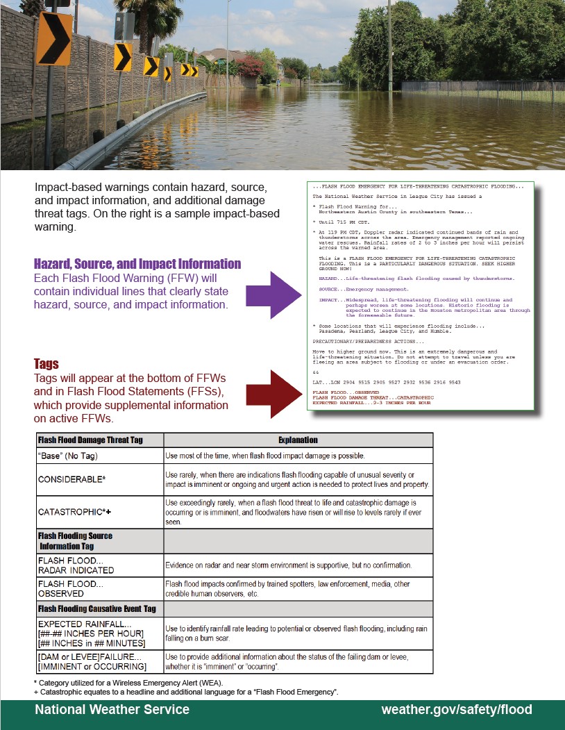 https://home.army.mil/stewart/download_file/view/77f48b3a-8617-421f-83f8-4d0eee2dcaee/1118
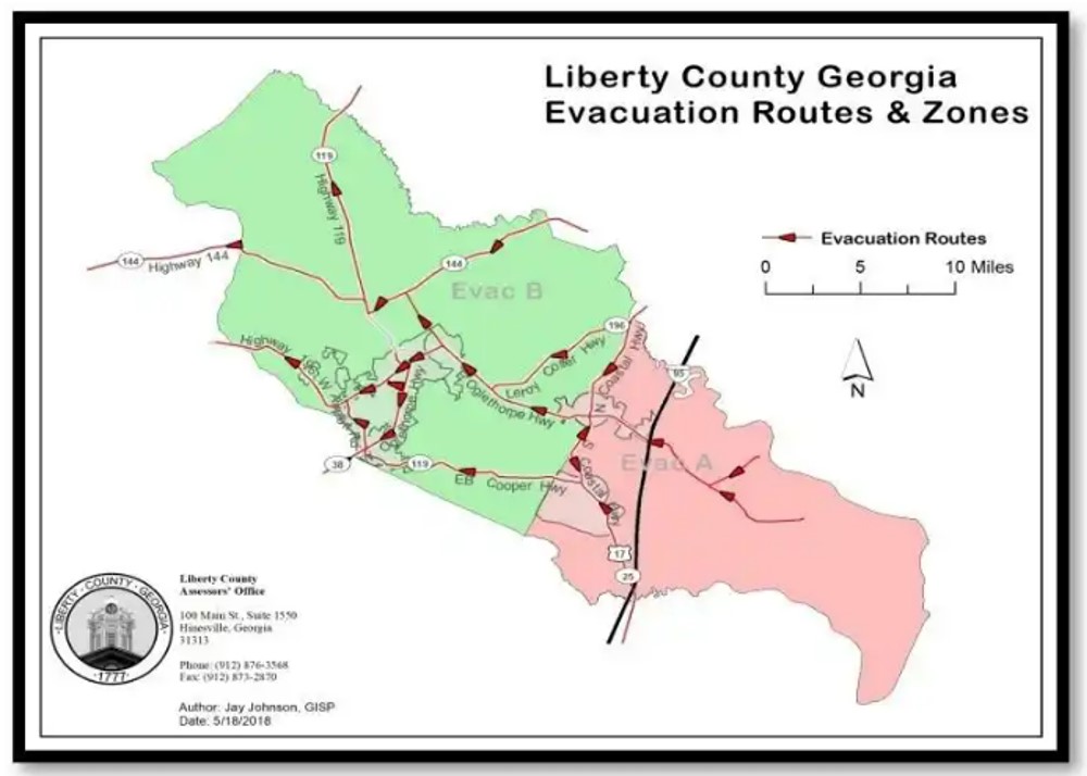
GDOT Flyer

Closing Tab
After The Storm


Post Storm Events
After a severe storm assess your situation. If you did not evacuate account for yourself and family members. Notify authorities of your condition, location and any safety issues. Military, DoD Civilians and dependents contact the Army Disaster Personnel Accountability and Assessment System (ADPAAS). Contact distant family or friends. Let them know you’re ok, location and plans, but don’t hang on the phone (might not be able to charge your mobile phone for some time).
As soon as any severe weather event has past (with in hours) local authorities surge emergence services composed of fire police units to assess local environmental hazards. The units look for any hazard that creates a danger to the population and damage to infrastructure. The will be looking for people needing help, any fire, structure damage, high water, power lines down, roads blocked, bridges damaged and loss of local utilities. The emergency services is normally heavy engaged post storm so if you are safe. Stay put and remain vigilant.
If you did evacuate the Georgia Emergency Management and Homeland Security Agency has stated a five phase re-entry for affected areas. (https://gema.georgia.gov/plan-prepare/re-entry)
It is recommended:
- · Continue listening to your local radio station for news and the latest updates.
- · If you evacuated, return home only when officials say it is safe.
- · Once home, drive only if necessary and avoid flooded roads and washed-out bridges. If you must go out, watch for fallen objects in the road, downed electrical wires, and weakened walls, bridges, roads, and sidewalks that might collapse.
- · Walk carefully around the outside of your home to check for loose power lines, gas leaks, and structural damage.
- · Stay out of any building if you smell gas, if floodwaters remain around the building, if the building or home was damaged by fire, or if the authorities have not declared it safe.
- · Carbon monoxide poisoning is one of the leading causes of death after storms in areas dealing with power outages. Never use a portable generator inside your home or garage. Review generator safety.
- · Use battery-powered flashlights. Do NOT use candles. Turn on your flashlight before entering a vacated building. The battery could produce a spark that could ignite leaking gas, if present.
Closing Tab
Information Source
AccuWeather
Army Disaster Personnel Accountability and Assessment System
Center for Disease Control and Prevention
Colorado State University (CSU)
- https://tropical.colostate.edu/forecasting⚠
DoW Hurricane-Preparedness -
Georgia Department of Transportation (GDOT) Evacuation Routes
Georgia Emergency Management-Homeland Security Agency
National Oceanic and Atmospheric Administration (NOAA)
-https://www.noaa.gov/news-release/2023-atlantic-hurricane-season-outlook⚠
Nation Weather Services (NWS) Charleston, SC.
The Old Farmer’s Almanac


