Follow our social media channels and My Army Post App as we continue with around the clock updates to keep you informed and safe
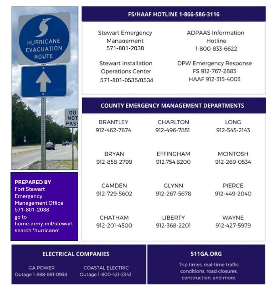
The 2025 Atlantic Hurricane Season is here, and forecasts call for another above average season. The time to prepare is now and the DPTMS Protection Team is available to conduct information briefs to units, Soldiers and Soldier/Family Readiness Groups and Command Steering Committee Meetings. Most of all we need to educate our Spouses on preparations and evacuation measures should it be needed. Please contact 571-801-2038 to request a briefing.
NOAA Map

HURRICANE

The 2025 Atlantic Hurricane Season is here, and forecasts call for another above average season. The time to prepare is now and the DPTMS Protection Team is available to conduct information briefs to units, Soldiers and Soldier/Family Readiness Groups and Command Steering Committee Meetings. Most of all we need to educate our Spouses on preparations and evacuation measures should it be needed. Please contact 571-801-2038 to request a briefing.
HURRICANE FORECASTS
AOML scientists prepare for an active 2025 hurricane season
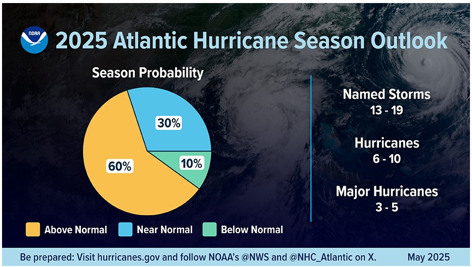
The 2025 Atlantic hurricane season started on June 1 and runs through November 30. NOAA predicts a 30% chance of a near-normal season, a 60% chance of an above-normal season, and a 10% chance of a below-normal season in the Atlantic basin this year:
NOAA’s Atlantic Oceanographic and Meteorological Laboratory (AOML) will work with partners across NOAA, academia, and private industry to gather critical data throughout the season and continue to advance hurricane models to protect lives and property.
- NOAA’s flagship hurricane forecast model, the Hurricane Analysis and Forecast System (HAFS), has been upgraded for the 2025 season. Developed by researchers at NOAA’s Atlantic Oceanographic and Meteorological Lab (AOML), the University of Miami’s Cooperative Institute for Marine and Atmospheric Studies (CIMAS), the National Weather Service’s Environmental Modeling Center and other NOAA partners, HAFS is a key tool for forecasters at the National Hurricane Center. The upgrade will improve forecasts of hurricane tracks, intensity, initial conditions, storm structure, and storm size. The new HAFS is expected to improve forecasts of rapid intensification, defined as an increase of winds by 30 knots in 24 hours, by 5-7%.
- While hurricane forecasters use the upgraded HAFS, researchers at AOML will be running an experimental HAFS to test the benefits of the next leap forward for the flagship hurricane forecast model.
- To improve the understanding and prediction of how hurricanes intensify, AOML, in partnership with CIMAS and private industries, is deploying new small aircraft drone systems, swarms of atmospheric profilers, and underwater gliders this season. These technologies will continue to advance our knowledge of hurricanes, fill critical data gaps, and improve hurricane forecast accuracy.
A team of scientists and forecasters, including scientists from AOML, work together to create the Atlantic hurricane season outlook each year. To read the full 2025 Atlantic Hurricane Season Outlook, please visit NOAA.gov. To dive deeper into the 2025 hurricane research plans, please visit NOAA Research.
Saffir-Simpson Hurricane Wind Scale
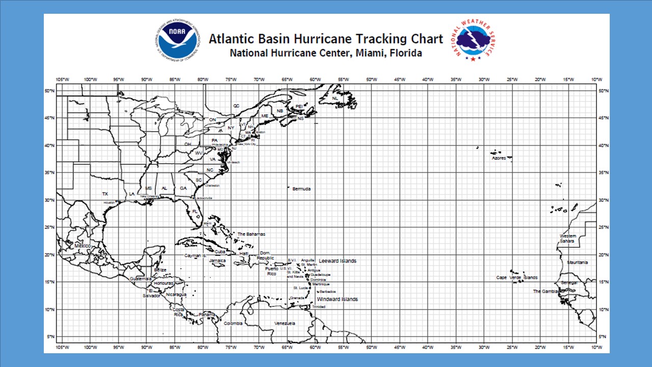
Tropical Weather Track
National Hurricane Center - Miami, FL.
WINTER STORMS

Winter Weather
Before Winter Weather
A storm can occur when family members are in different places, so develop a family communications plan.
- Make a Ready kit for at least three days of self-sufficiency.
- Familiarize yourself with the terms that are used to identify winter weather.
- Keep space heater safety in mind: Use electric space heaters with automatic shut-off switches and non-glowing elements. Remember to keep all heat sources at least three feet away from furniture and drapes.
Prepare your home:
- Make sure your home is well insulated and that you have weather stripping around your doors and window sills to keep the warm air inside.
- Make sure you have a working carbon monoxide detector.
- If you have a wood burning fireplace, consider storing wood to keep you warm if winter weather knocks out your heat. Also, make sure you have your chimney cleaned and inspected every year.
- Have at least one of the following heat sources in case the power goes out:
- Extra blankets, sleeping bags and warm winter coats
- Fireplace or wood-burning stove with plenty of dry firewood, or a gas log fireplace
- Kerosene heater, with proper ventilation.
Prepare your vehicle:
- Fully winterize your vehicle: Have a mechanic check antifreeze, brakes, heater and defroster, tires, and windshield wipers to ensure they are in good shape. Keep your gas tank at least half full.
- Keep an extra Ready kit in the trunk of your car. In addition to the basic essentials, consider adding a portable cell phone charger, ice scraper, extra blanket, sand for traction and jumper cables.
- Make sure you have a cell phone with an emergency charging option (car, solar, hand crank, etc.) in case of a power failure.
- People who depend on electricity to operate medical equipment should have alternate arrangements in place in case power is out for an extended period of time.
- Plan to check on elderly/disabled relatives and neighbors.
- Plan to bring Pets inside.
- Know where the manual release lever of your electric garage door opener is located and how to operate it in case you lose power.
- Fill a gallon container with water and place them in the freezer to help keep food cold.
During Winter Weather:
- Listen to NOAA Weather Radio to stay informed of winter weather watches and warnings. Also monitor commercial radio, television, and the Internet.
- Check on elderly/disabled relatives and neighbors.
- Bring pets inside.
- Keep in mind that during a severe winter storm it could be hours, or even days, before emergency personnel are able to reach you. Don’t call 911 for information or to report a power outage.
- Allow faucets to drip a little during cold weather to avoid freezing.
- Open cabinet doors to allow heat to get to un-insulated pipes under sinks and appliances near exterior walls.
- Winter storms are often accompanied by power outages. Always exercise caution when using alternative light and heating sources:
- Use flashlights during power outages instead of candles to prevent the risk of fire, and have plenty of extra batteries on-hand.
- Never use an oven to heat your home. Never bring portable generators, camp stoves and grills into your home; they should only be used outside. Keep them at least 20 feet away from your home’s windows, doors and vents to prevent deadly carbon monoxide poisoning.
- Use flashlights during power outages instead of candles to prevent the risk of fire, and have plenty of extra batteries on-hand.
- Follow tips for keeping food safe in an emergency.
- Watch for frostbite. Warning signs include white or grayish-yellow skin, numbness and skin that feels unusually firm or waxy. If symptoms are detected, get medical help immediately. If medical help is not available, get the victim to a warm location and immerse the affected area in warm water. Frostbitten areas are numb and can be easily burned so avoid using heating pads, fireplaces or radiators for warming. Do not rub the frostbitten area; this could cause more damage.
- Watch for signs of hypothermia, including shivering, memory loss, fumbling hands, slurred speech and drowsiness. If the victim’s body temperature is below 95 degrees, seek medical help immediately. If medical help is not available, get the victim to a warm location, remove wet clothing, warm the center of the body first using an electric blanket and if conscious, give the victim warm, non-alcoholic beverages.
- Follow directions from local officials about driving during snow and ice storms, and drive with caution.
Winter Weather Driving :
Minimize travel during winter weather. If you can postpone your trip or if it is non-essential, stay in when the weather is really bad. If you don’t have somewhere you have to be, watch the snow from indoors.
Learn more about winter weather driving…
Winter Weather Terms:
Knowing winter weather terms helps you know when to put your personal preparedness plan into action. There are three key winter weather terms to know: winter storm watch, winter storm advisory and winter storm warning.
Learn more about winter weather terms…
*Source: Georgia Emergency Management and Homeland Security Agency - https://gema.georgia.gov/
Tornadoes

Tornado Watch /Tornado Warning issued by the National Weather Service (NWS)
Be Weather-Ready:
Check the forecast regularly to see if you're at risk for tornadoes. Listen to local news or a NOAA Weather Radio to stay informed about tornado watches and warnings.
Create a Communications Plan:
Have a family plan that includes an emergency meeting place and related 'what to do if...' information. If you live in a mobile home or home without a basement, identify a nearby safe building you can get too quickly, such as a concrete or brick structure.
Pick a safe room in your home:
A safe room can be a basement, storm cellar, or an interior room on the lowest floor with no windows. Make your family plan at: https://www.ready.gov/make-a-plan
Practice Your Plan:
Conduct a family severe weather drill regularly, so everyone knows what to do if a tornado is approaching. Make sure all members of your family know where to go, when tornado warnings are issued. Don't forget your pets.
Prepare Your Home:
Consider having your safe room reinforced. You can find plans for reinforcing an interior space on the Federal Emergency Management Agency (FEMA) website
https://www.ready.gov/shelter
Lightning

Lightning Safety
Lightning Threat
Minimizing Lightning Risk
Lightning Strike Victims
Flooding

Fort Stewart and Hunter Army Airfield
Flash Flood Watch
A Flash Flood Watch is issued to indicate current or developing conditions that are favorable for flash flooding. The occurrence is neither certain nor imminent. A watch is typically issued within several hours to days ahead of the onset of possible flash flooding.
Flood Watch
A Flood Watch is issued to indicate current or developing conditions that are favorable for flooding. The occurrence is neither certain nor imminent. A watch is typically issued within several hours to days ahead of the onset of possible flooding. In situations where a river or stream is expected to be the main source of the flooding, forecast confidence may allow for a Flood Watch to be issued several days in advance.
Flash Flood Warning
A Flash Flood Warning is issued to inform the public, emergency management and other cooperating agencies that flash flooding is in progress, imminent, or highly likely. Flash Flood Warnings are urgent messages as dangerous flooding can develop very rapidly with a serious threat to life and/or property. Flash Flood Warnings are usually issued minutes to hours in advance of the onset of flooding.
Flood Warning
A Flood Warning is issued to inform the public of flooding that poses a serious threat to life and/or property. A Flood Warning may be issued hours to days in advance of the onset of flooding based on foretasted conditions. Floods occurring along a river usually contain river stage (level) forecasts.
Flood Advisory
A Flood Advisory is issued when a flood event warrants notification but is less urgent than a warning. Advisories are issued for conditions that could cause a significant inconvenience, and if caution is not exercised could lead to situations that may threaten life and/or property.
Coastal/Lake shore Hazard Message
Coastal/Lake shore Hazard Message provide the public with detailed information on significant coastal/lake shore events. Coastal/Lake shore events impact land-based and near shore interests along much of the United States coastline. This product can be issued as a watch, warning or advisory and follows the same "Be Aware, Be Prepared, Take Action" definitions as with other National Weather Service (NWS) Watches, Warnings and Advisories (WWA). A Watch is issued when flooding with significant impacts is possible. Warnings are issued when flooding posing a serious threat to life and property is occurring, imminent or highly likely.
Special Weather Statement
Special Weather Statements provide the public with information concerning ongoing or imminent weather hazards, which require a heightened level of awareness or action, but do not rise to the level of watch, warning or advisory.
–Hydrologic Outlook
Two types:
1. Short-term (1 to 7 days) Hydrologic Outlooks can be issued to alert thepublic of the potential for flooding in the near-term such as when heavyrainfall is forecast that could result in flooding or aggravate an existingflood if it occurs.
2. Long-term (weeks to months) Hydrologic Outlooks may also provide river orreservoir level and/or flow information. This information could be used forwater supply concerns or projection of snowmelt flooding.
–Hazardous Weather Outlook
TheHazardous Weather Outlook is a single source of information regarding expectedhazardous weather through seven days. It can include information on severestorms, heavy rain, flooding, tropical storms, winter weather, high winds, fireweather and marine hazards.
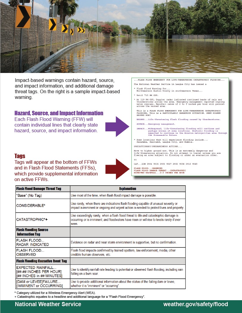
INPACT-BASE Flash Flood Warnings
After The Storm

- · Continue listening to your local radio station for news and the latest updates.
- · If you evacuated, return home only when officials say it is safe.
- · Once home, drive only if necessary and avoid flooded roads and washed-out bridges. If you must go out, watch for fallen objects in the road, downed electrical wires, and weakened walls, bridges, roads, and sidewalks that might collapse.
- · Walk carefully around the outside of your home to check for loose power lines, gas leaks, and structural damage.
- · Stay out of any building if you smell gas, if floodwaters remain around the building, if the building or home was damaged by fire, or if the authorities have not declared it safe.
- · Carbon monoxide poisoning is one of the leading causes of death after storms in areas dealing with power outages. Never use a portable generator inside your home or garage. Review generator safety.
- · Use battery-powered flashlights. Do NOT use candles. Turn on your flashlight before entering a vacated building. The battery could produce a spark that could ignite leaking gas, if present.
WINTER STORM ENZO

UPDATE 5pm January 24, 2025:
 UPDATE 5pm January 24, 2025: As we recover from Winter Storm Enzo, our gates and facilities will begin resuming normal hours starting tomorrow. Roads on the installation are better but may still have ice and snow on them. Georgia Highways 119 and 144 are still restricted routes. If you must travel, exercise extreme caution on the roads. Bridges and overpasses can freeze quickly, and you may encounter ice on the roads. The installation will resume normal operations Jan. 27. Follow our digital platforms and download the My Army Post App for updated installation status and near real time updates.
UPDATE 6pm January 23, 2025:
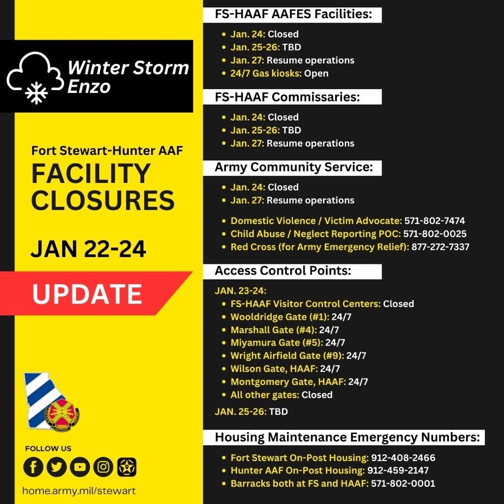
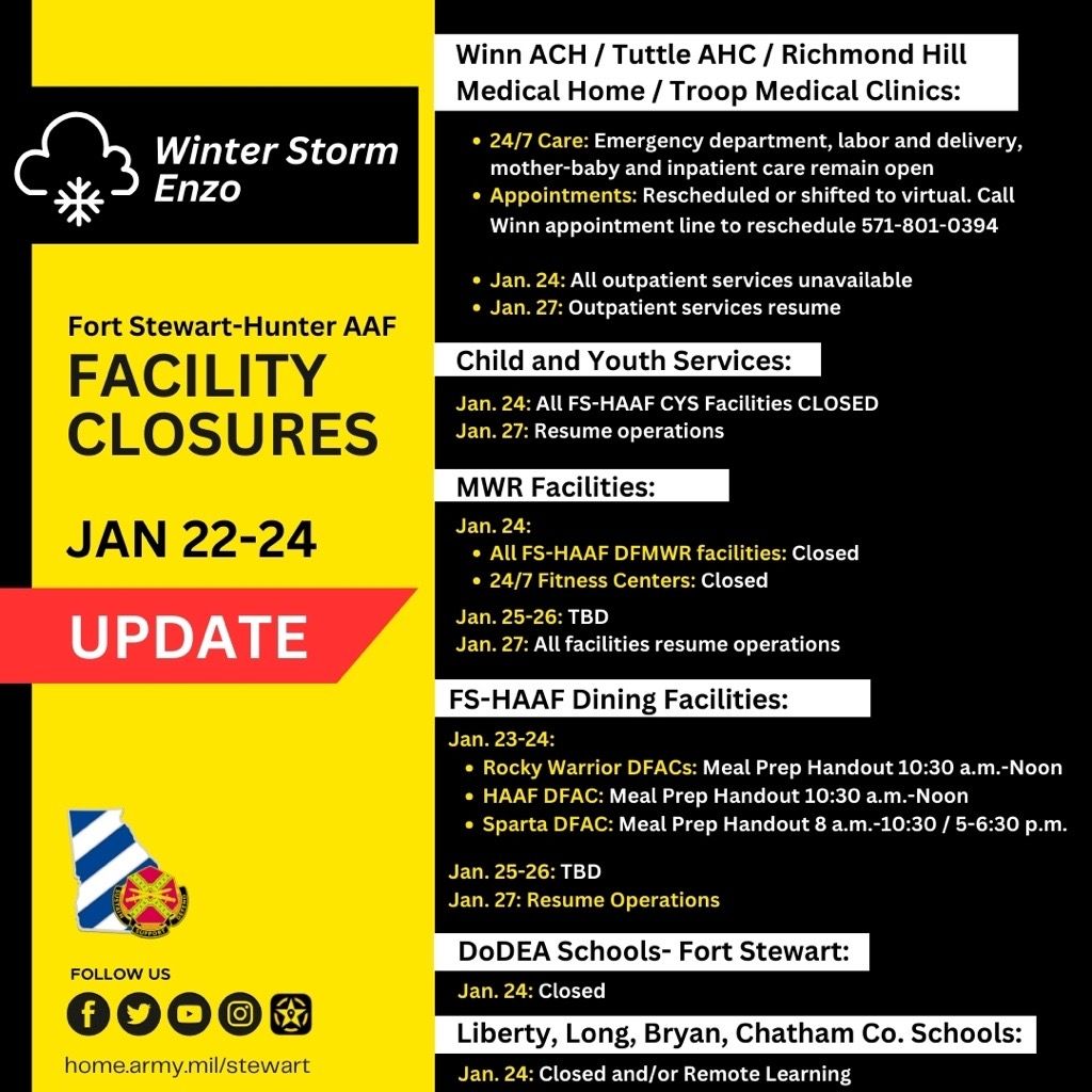 UPDATE 6pm January 23, 2025: On Friday, Jan. 24, Fort Stewart-Hunter Army Airfield will remain closed due to snow and icy conditions from Winter Storm Enzo. Stay home and stay safe. The installation will resume normal operations Monday, Jan. 27. A determination will be made regarding the weekend operations of our gates, AAFES, DECA and FMWR services tomorrow. Regarding Winn Army Community Hospital, Tuttle Army Health Clinic, Richmond Hill Medical Home, and Troop Medical Centers:
- The clinics and pharmacies remain closed Friday.
- The Emergency Department, Labor & Delivery, Mother-Baby, and inpatient ward remain open 24/7.
- Outpatient services will resume Monday at 7:30 a.m.
- In-person appointments are being rescheduled, and virtual appointments will be used where possible.
- If you must travel, exercise extreme caution on the roads. Bridges and overpasses can freeze quickly and expect formation of black ice on the roads.
- Follow our digital platforms and download the My Army Post App for updated installation status and near real time updates.
UPDATE 11am January 23, 2025:
 UPDATE 11am January 23, 2025: On Friday, Jan. 24, Fort Stewart-Hunter Army Airfield anticipates a delayed open at 11 a.m. for Soldiers and civilian workforce. Key and essential personnel will report at 10 a.m. Leaders are empowered to support their Soldiers as mission dictates based on individual situations. Contact your first line supervisor or chain of command for reporting instructions. If you must travel today, exercise extreme caution on the roads. Bridges and overpasses can freeze quickly and expect formation of black ice on the roads. Follow our digital platforms and download the My Army Post App for updated installation status and near real time updates.
UPDATE 11pm January 22, 2005:
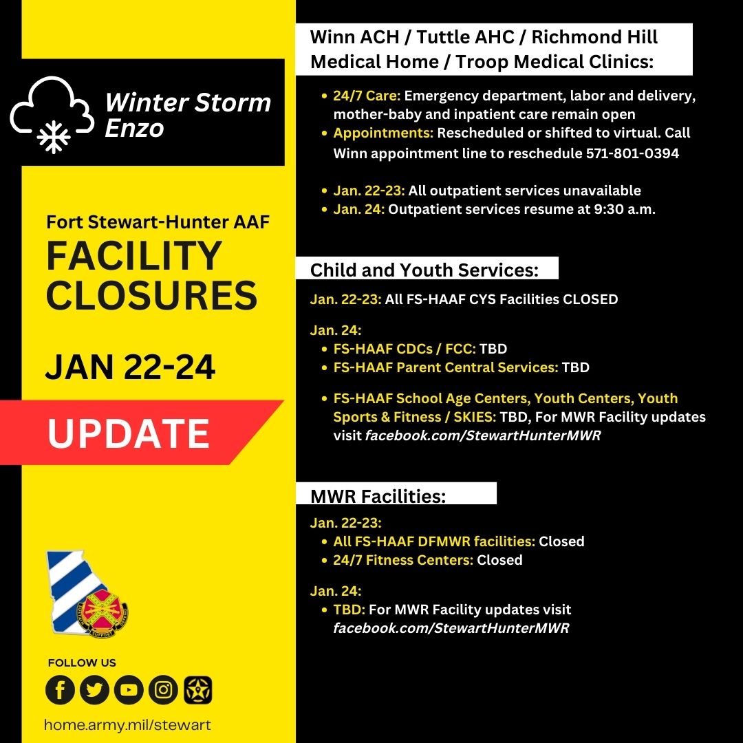
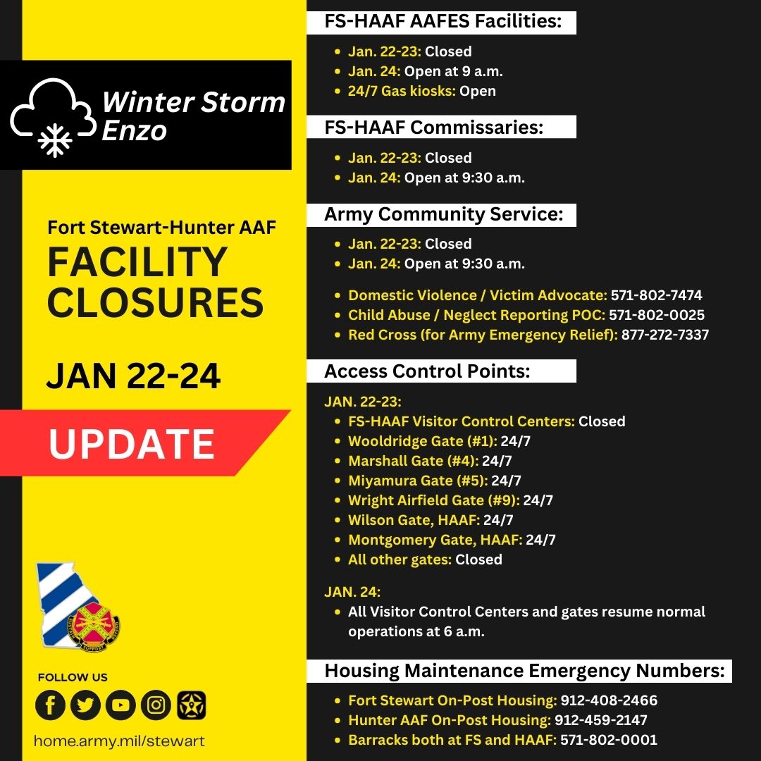
 UPDATE 11PM January 22, 2025: Fort Stewart-Hunter Army Airfield will remain closed tomorrow, Jan. 23 due to snow and icy conditions. See the updated facility information below for details. Should snow or icy conditions continue to impact the installation and surrounding areas, we will provide updates here regarding any additional delays or closures. Contact your first line supervisor or chain of command for reporting instructions. Follow our digital platforms and download the My Army Post App for updated installation status and near real time updates. Stay safe!
UPDATE 12pm January 22, 2025:
UPDATE 12pm January 22, 2025: Thursday, Jan. 23, Fort Stewart-Hunter Army Airfield will remain closed due to snow and icy conditions resulting from Winter Storm Enzo. Stay home and stay safe. On Friday, Jan. 24, Fort Stewart-Hunter Army Airfield anticipates a delayed open at 9:30 a.m. for Soldiers and civilian workforce. Leaders are empowered to support their Soldiers as mission dictates based on individual situations. Should snow or icy conditions continue to impact the installation and surrounding areas, we will provide updates here regarding any additional delays or closures. Contact your first line supervisor or chain of command for reporting instructions. If you must travel, exercise extreme caution on the roads. Bridges and overpasses can freeze quickly and expect formation of black ice on the roads. Follow our digital platforms and download the My Army Post App for updated installation status and near real time updates.
UPDATE 6am January 22, 2025:
UPDATE 6am January 22, 2025: Our Directorate of Emergency Services has directed emergency vehicle movement only on the installation as road conditions are hazardous at this time. Due to snow accumulation and icy areas there is limited emergency response. Stay safe and stay inside.
WINTER WEATHER ALERT: 12pm January 21, 2025
WINTER WEATHER ALERT: Weather forecasts are predicting the potential for winter conditions in our area beginning this evening. We are closely monitoring the situation to ensure the safety of our Soldiers and Families at Fort Stewart-Hunter Army Airfield. If you must travel, exercise extreme caution on the roads. Bridges and overpasses can freeze quickly and expect formation of black ice on the roads. Follow the official Fort Stewart-Hunter Army Airfield and 3rd Infantry Division digital platforms and download the My Army Post app for updated installation status and near real time updates.
- On Tuesday, Jan. 21, Fort Stewart-Hunter Army Airfield Soldiers, and civilian workforce will be released no later than 4 p.m. Please plan accordingly. All AAFES facilities and the commissaries will also close at 4 p.m. Leaders are empowered to release Soldiers as mission dictates based on individual situations, as necessary.
- On Wednesday, Jan. 22, Fort Stewart-Hunter Army Airfield will be closed due to anticipated snow and ice. Stay home and stay safe.
- On Thursday, Jan. 23, Fort Stewart-Hunter Army Airfield anticipates a delayed open at 1 p.m. for Soldiers and civilian workforce. Contact your first line supervisor or chain of command for reporting instructions. AAFES facilities and the commissaries are planning to reopen at noon Thursday. Should snow or icy conditions continue to impact the installation and surrounding areas, we will provide updates here regarding any additional delays or closures.
RESTRICTED TRAVEL ON STATE ROADS 119/144
Avoid using Highways 119 & 144 beginning at 7 p.m. tonight through 8 a.m., Thursday, Jan. 23. Highways 119 and 144 are off-limits for military personnel with the exception of official duties and emergencies.
HOUSING MAINTENANCE EMERGENCY NUMBERS
Fort Stewart On-Post Housing: 912-408-2466
Hunter AAF On-Post Housing: 912-459-2147
Barracks both at FS and HAAF: 571-802-0001
FORT STEWART-HUNTER AAF FACILITY CLOSURES- JAN 21-23:
FS-HAAF DFAC Hours
Jan. 21:
- DFACs: Regular hours of operation, Closes at 4:30 p.m.
- Kiosks: Close at 7 p.m.
Jan. 22:
- DFACs & Kiosks: Closed, MREs available at DFACs & through BDEs
Jan. 23:
- DFACs: Holiday hours of operation
- Brunch: 9:30 a.m.-1 p.m.
- Supper: 5-6:30 p.m.
- Brunch: 9:30 a.m.-1 p.m.
- Kiosks: 9:30 a.m.- 5:30 p.m.
Winn ACH / Tuttle AHC / Richmond Hill Medical Home / Troop Medical Clinics:
- Jan. 21: All clinics and pharmacies close at 4 p.m.
- Jan. 22: All outpatient services unavailable
- Jan. 23: Outpatient services resume at 1 p.m
- 24/7 Care: Emergency department, labor and delivery, mother-baby and inpatient care remain open
- Appointments: Rescheduled or shifted to virtual. Call Winn appointment line to reschedule 571-801-0394
Child & Youth Services:
Jan. 21:
- FS-HAAF CDCs / FCC: 6 a.m.-4 p.m. Last child must be picked up by 4 p.m.
- FS School Age Center: Children will be picked up from Liberty Co. Elementary and DoDEA schools. Last child must be picked up by 4 p.m.
- HAAF School Age Center: 6 a.m.-4 p.m. Last child must be picked up by 4 p.m.
- FS-HAAF Youth Centers: Closed
- FS-HAAF Youth Sports & Fitness / SKIES: 7 a.m.-4 p.m. All practices/classes canceled
- FS-HAAF Parent Central Services: 7 a.m.-4 p.m.
Jan. 22:
- All FS-HAAF CYS Facilities CLOSED
Jan. 23:
- FS-HAAF CDCs / FCC: Noon-6 p.m.
- FS-HAAF School Age Centers: Noon-6 p.m.
- Stewart Youth Center: 1-6 p.m.
- HAAF Youth Center: 1-6 p.m.
- FS-HAAF Youth Sports & Fitness / SKIES: 1 p.m. to close Practices/classes resume
- FS-HAAF Parent Central Services: 1-4 p.m.
DFMWR Facilities:
Jan. 21:
- Taylors Creek / Hunter Golf Courses: Close at 3 p.m.
- FS-HAAF Physical Fitness Centers: Close at 1 p.m., 24/7 access remains open
- All other FS-HAAF DFMWR facilities: Close at 4 p.m.
Jan. 22:
- All FS-HAAF DFMWR facilities: Closed
- 24/7 Fitness Centers: Closed
Jan. 23:
- Newman / Johnson / Tominac Fitness: Open at 1 p.m.
- 24/7 Physical Fitness Centers: Open
- Pet Boarding: Open
- FS-HAAF Clubs, Leisure Travel, Golf Courses, Bingo, Marne Lanes Bowling, Corkan Recreation and Auto Skills: Closed
FS-HAAF Army Community Service:
- Jan. 21: Closes at 4 p.m.
- Jan. 22: Closed
- Jan. 23: All ACS facilities resume normal operations at 1 p.m.
- Domestic Violence/ Victim Advocate Services: 571-802-7474
- Child abuse/neglect: 571-802-0025
- Red Cross (Army Emergency Relief): 877-272-7337
FS-HAAF AAFES Facilities:
- Jan. 21: Close at 4 p.m.
- Jan. 22: Closed
- Jan. 23: Open at noon
- 24/7 Fuel Kiosks will remain open
FS-HAAF Commissaries:
- Jan. 21: Close at 4 p.m.
- Jan. 22: Closed
- Jan. 23: Open at noon
Army Community Service:
- Jan. 21: Close at 4 p.m.
- Jan. 22: Closed
- Jan. 23: Open at 1 p.m.
- Domestic Violence / Victim Advocate Hotline: 571-802-7474
- Child Abuse / Neglect Reporting POC: 571-802-0025
- Red Cross (for Army Emergency Relief): 877-272-7337
FS-HAAF Access Control Points:
Jan. 21:
- FS-HAAF Visitor Control Centers: Close at 4 p.m.
- Britt Gate (#3): Close at 6 p.m.
- Barkley Gate (#8): Close at 6 p.m.
- Rio Gate, HAAF: Close at 6 p.m.
- Wooldridge Gate (#1): 24/7
- Marshall Gate (#4): 24/7
- Miyamura Gate (#5): 24/7
- Wright Airfield Gate (#9): 24/7
- Wilson Gate, HAAF: 24/7
- Montgomery Gate, HAAF: 24/7 beginning at 6 p.m.
- All other gates: Closed
Jan. 22:
- FS-HAAF Visitor Control Centers: Closed
- Wooldridge Gate (#1): 24/7
- Marshall Gate (#4): 24/7
- Miyamura Gate (#5): 24/7
- Wright Airfield Gate (#9): 24/7
- Wilson Gate, HAAF: 24/7
- Montgomery Gate, HAAF: 24/7
- All other gates: Closed
Jan. 23:
- Visitor Control Centers and gates resume normal operations at 6 a.m.
- Rio Road Gate resumes operations at 1 p.m.
School Closures:
For additional updates follow your district’s website and social media platforms.
DoDEA Schools- Fort Stewart
- Jan. 21: 2 p.m. early release, after school activities cancelled
- Jan. 22: Closed
- Jan. 23: Closed
Daily monitoring for additional closures
Liberty County Schools
- Jan. 21: Half day instruction
- Jan. 22-23: Remote learning
Daily monitoring for additional closures
Bryan County Schools
- Jan. 21: 1-hour early release, after school activities cancelled
- Jan. 22: Closed
Daily monitoring for additional closures
Chatham County Schools
- Jan. 21-23: Remote learning
Daily monitoring for additional closures
Long County Schools
- Jan. 21-22: Closed
Daily monitoring for additional closures
Hurricane Milton Updates
Access Control Point Update:

ACCESS CONTROL POINT UPDATE: The Rio Gate at Hunter Army Airfield will be closed from 6 a.m. – 6 p.m. on Friday, October 11. The gate will be closed to support debris clean up from Hurricane Milton on Rio Road. Rio Road will also be closed during this time.
Hurricane Milton Update:

Hurricane Milton Update 12am: 9 Oct 2024
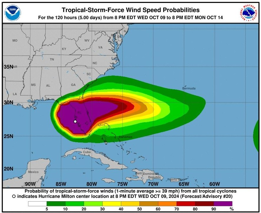 As of 12 a.m., Hurricane Milton is currently 75mi SW of Orlando FL, moving ENE through Florida. The Fort Stewart-Hunter Army Airfield area is expecting an an inch or less of rainfall throughout the morning with sustained winds of 23 MPH and gusts up to 35 MPH.While impacts to our area are expected to be minimal, keep an eye on your property and on treelimbs and branches that could still be low from previous storms. In the event you must report a power outage or other damage to your on-post home or facility, call the DPW non-emergency line at 571-802-0001.
- Holbrook Campground and Lotts Island will remain closed today and Child Development Centers will operate on a regular schedule. Follow the Fort Stewart-Hunter Army Airfield Family, Morale, Welfare and Recreation social media platforms for additional updates.
- DODEA schools will operate on a regular schedule today.
- AAFES and the commissaries will open at scheduled times today.
Hurricane Milton Update 11pm: 8 Oct 2024
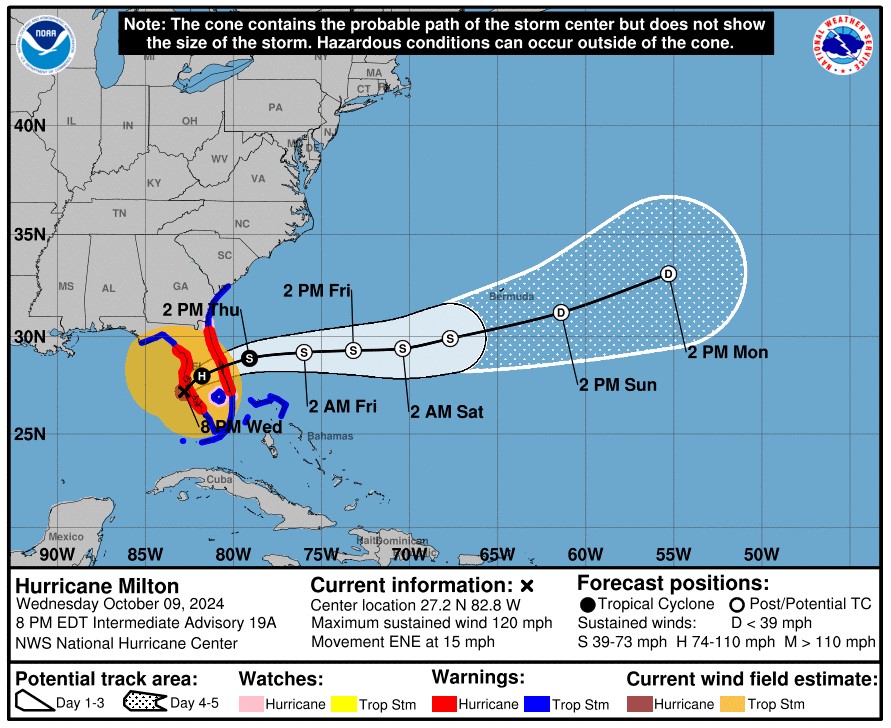 As of 11 a.m., Hurricane Milton is 190 miles SW of Tampa, moving east towards Florida. Forecasted effects for our area include an inch or less of rainfall starting tonight through tomorrow with sustained winds at 23 mph and gusts up to 30 mph from 10 a.m. to 4 p.m. tomorrow.
- Holbrook Campground and Lotts Island will close today in preparation for the storm and will remain closed tomorrow. Child Development Centers will operate on a regular schedule tomorrow. Follow the Fort Stewart-Hunter Army Airfield Family, Morale, Welfare and Recreation social media platforms for additional updates.
- DODEA schools will operate on a regular schedule tomorrow.
- AAFES and the commissaries will open at scheduled times tomorrow.
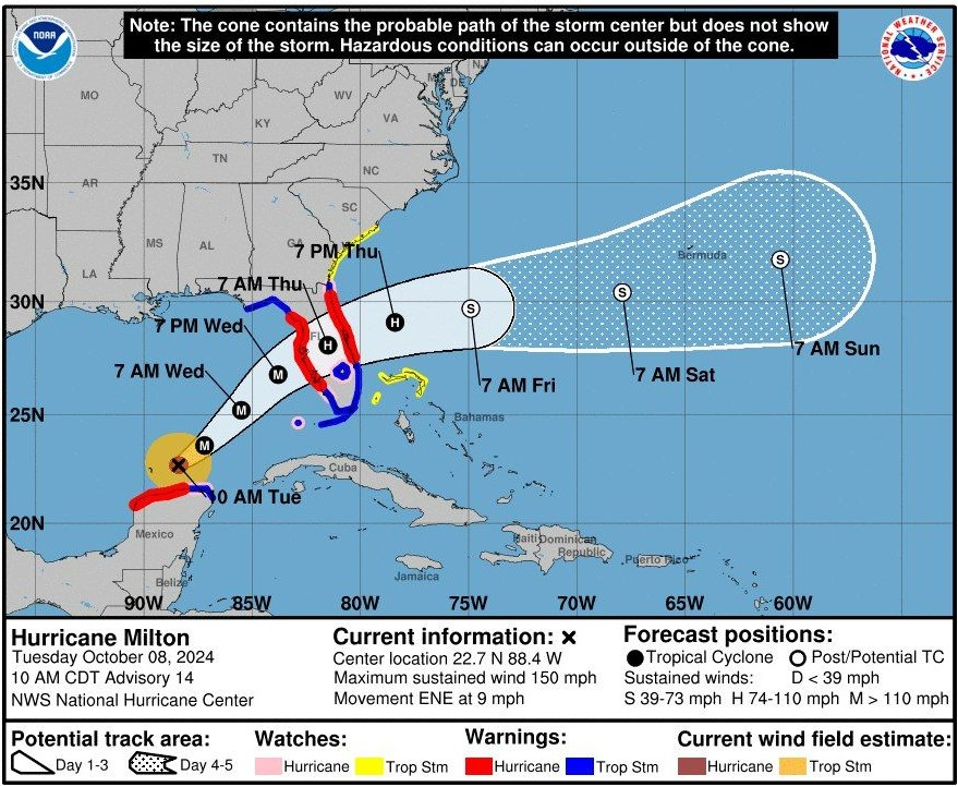
Hurricane Milton 1330: 8 Oct 2024
Hurricane Helene Information
Hurricane Helene Assistance: Closed 6 Nov 2024

Hurricane Helene Relief:
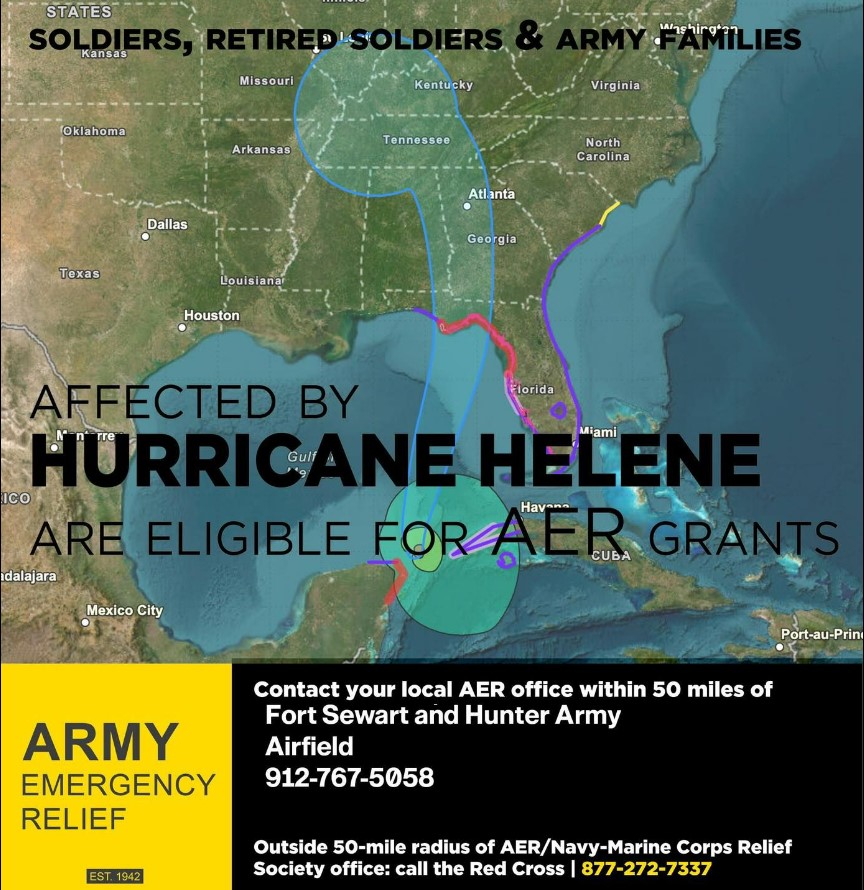
HURRICANE HELENE-RELIEF GRANTS AVAILABLE FOR SOLDIERS, RETIRED SOLDIERS, ARMY FAMILIES - Army Emergency Relief Headquarters approved disaster assistance to eligible individuals impacted by Hurricane Helene.
Eligible Army personnel may be provided financial assistance to assist with expenses associated with basic essential needs to sustain oneself after the storm.
Those eligible include:
- Soldiers on active duty and their eligible Family members
- Soldiers retired from active duty because of longevity and their eligible Family members
- Retired Army Reserve and National Guard Soldiers receiving retired pay and their Family members
- Medically retired Soldiers and their dependents, including those placed on the Permanent Disability Retired List or Temporary Disability Retirement List
- Surviving spouses and children of Soldiers who died while on active duty (including those on Title 10 Orders) or in an eligible retired status
- Members of the Reserve Component of the Army (National Guard and Army Reserve under Title 10 U.S.C) on continuous active duty for more than 30 consecutive days and their eligible Family members
How to get help:
Contact your local AER office:
- Fort Stewart, Georgia: 912-767-5058
- Those who aren’t located near an AER office, but are located within 50 miles of a Navy or Marine Corps base can reach out to that installation’s Navy-Marine Corps Relief Society.
- Outside the 50-mile radius of an Army installation or Navy/Marine Corps base: contact the American Red Cross at 1-877-272-7337. AER distributes emergency financial assistance through the Red Cross where or when an AER office is not available.
Debris Removal:
 The Directorate of Public Works is actively removing storm debris and trees on the installation. Motorists are asked to exercise caution while traveling, especially around the 3rd Infantry Division Headquarters (Bldg. 1), GA HWYs 144 and 119 on Fort Stewart, and Rio Road on Hunter Army Airfield, as this work will continue over the next several days.
Tropical Storm Helene 8 a.m. 27 Sep. 2024 update:
 Tropical Storm Helene 8 a.m. update:
Friday, Sept. 27 Installation Work Call Update:
 Friday, Sept. 27 Installation Work Call Update:All Fort Stewart-Hunter Army Airfield Emergency Essential personnel (Soldiers and Civilians) should report to their already scheduled shifts for the day. All other personnel are asked to shelter in-place until further notice. For questions regarding your work status, contact your chain of command.
Hurricane Helene Update - 26 Sep 2024 1PM:
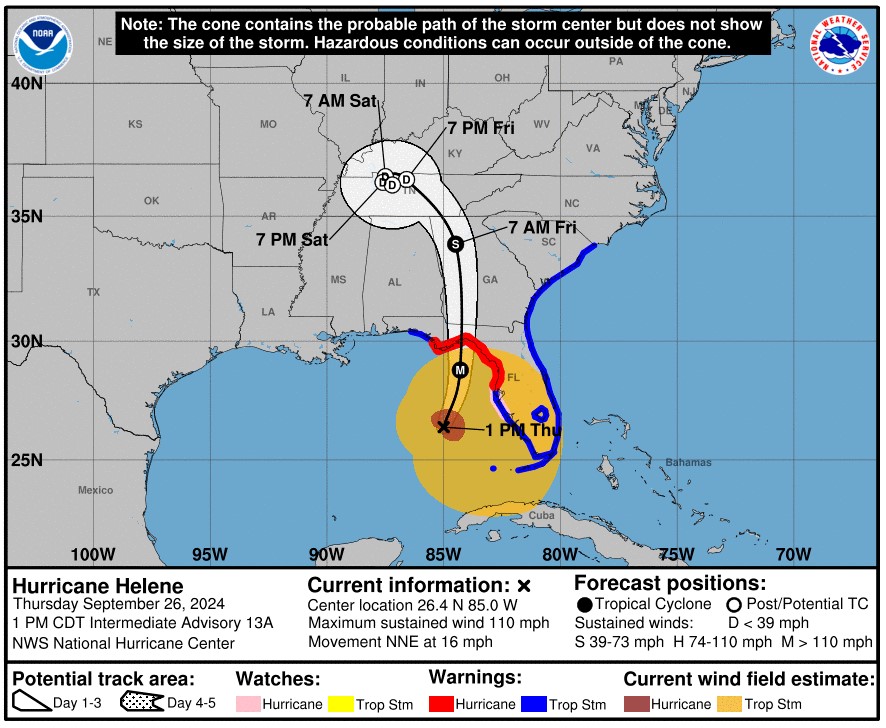 Here are the latest updates on the impacts from Hurricane Helene.
There is a high risk for tornadoes associated with Helene. The risk for tornadoes will increase this afternoon and peak tonight into early Friday morning.
Expect tropical storm force winds, with gusts between 40 to 60 mph. Wind speeds should peak late tonight as the center of Helene moves across central Georgia.
Clusters of showers associated with Helene are impacting the region.
Expect an increase in rain intensity throughout the remainder of the evening.
Installation status follows:
Avoid using State Road 119 & 144 during the hours of 10 p.m. until 7 a.m. Highways 119 and 144 are off-limits for military personnel with the exception of official duties and emergencies.
Fort Stewart and Hunter Army Airfield - Bingo canceled tonight.
Fort Stewart and Hunter Army Airfield - Golf Courses are closed today.
Fort Stewart and Hunter Army Airfield – Bowling Centers to close at 4 p.m.
Club Stewart and Hunter Club closing at 4 p.m.
iSportsman activities/ registration closed at 4 p.m.
Fort Stewart Auto Skills Center is closed.
Fitness Centers - Johnson, Tominac, Newman – close at 4 p.m. (24/7 service still available)
Fort Stewart Corkan Recreation Area closed.
Hurricane Helene Update: 10AM 26 Sept. 2024
Here are the latest updates on the impact from Hurricane Helene.
A tornado watch has been issued until 9 p.m.
There is a high risk for tornadoes associated with Helene. The risk for tornadoes will increase this afternoon and peak tonight into early Friday morning.
Expect tropical storm force winds, with frequent gusts of 40 to 60 mph. Wind speeds should peak late tonight as the center of Helene moves across central Georgia.
Both Fort Stewart and Hunter Army Airfield Education Centers will close today at 4 p.m. All evening classes will be canceled at both locations.
The Marne Chapel will close today at 3 p.m. Religious services are canceled this evening.
No after school activities for DODEA
Commissary is operating on a normal schedule and will close at 8 p.m.
Hunter Army Airfield will close Rio and Wilson gates at 6 p.m.
The Montgomery Gate will be open 24 hours.
The following gates on Fort Stewart will be closed at 6.p.m.
Gate 3 - Britt Gate
Gate 4B – 2ABCT PT Gate
Gate 4C – 2ABCT PT Gate
Gate 7 – McGarr Gate
Gate 8 – Barkley Gate
Continue to monitor the official social media channels of Fort Stewart and Hunter Army Airfield for
Tropical Storm Helene, maximum telework
 Due to Tropical Storm Helene, maximum telework is authorized for U.S. Army Garrison personnel and other tenant organizations. U.S. Army Garrison directorates will continue to provide customer service to our Soldiers and Families both Thursday, Sept. 26 and Friday, Sept. 27. Contact your chain of command or first-line supervisor for reporting information. DODEA schools are open Thursday, Sept. 26 and will recognize a student holiday, Friday, Sept. 27.Medical Treatment Facility personnel will stand by for reporting guidance. A decision is expected soon for MTF personnel. If you have a question regarding operating status of a facility tomorrow or Friday, it is recommended to call the facility beforehand. AAFES and DECA facilities will operate with normal hours Thursday, Sept. 26.
Tropical Storm Watch: Tropical Storm Helene:
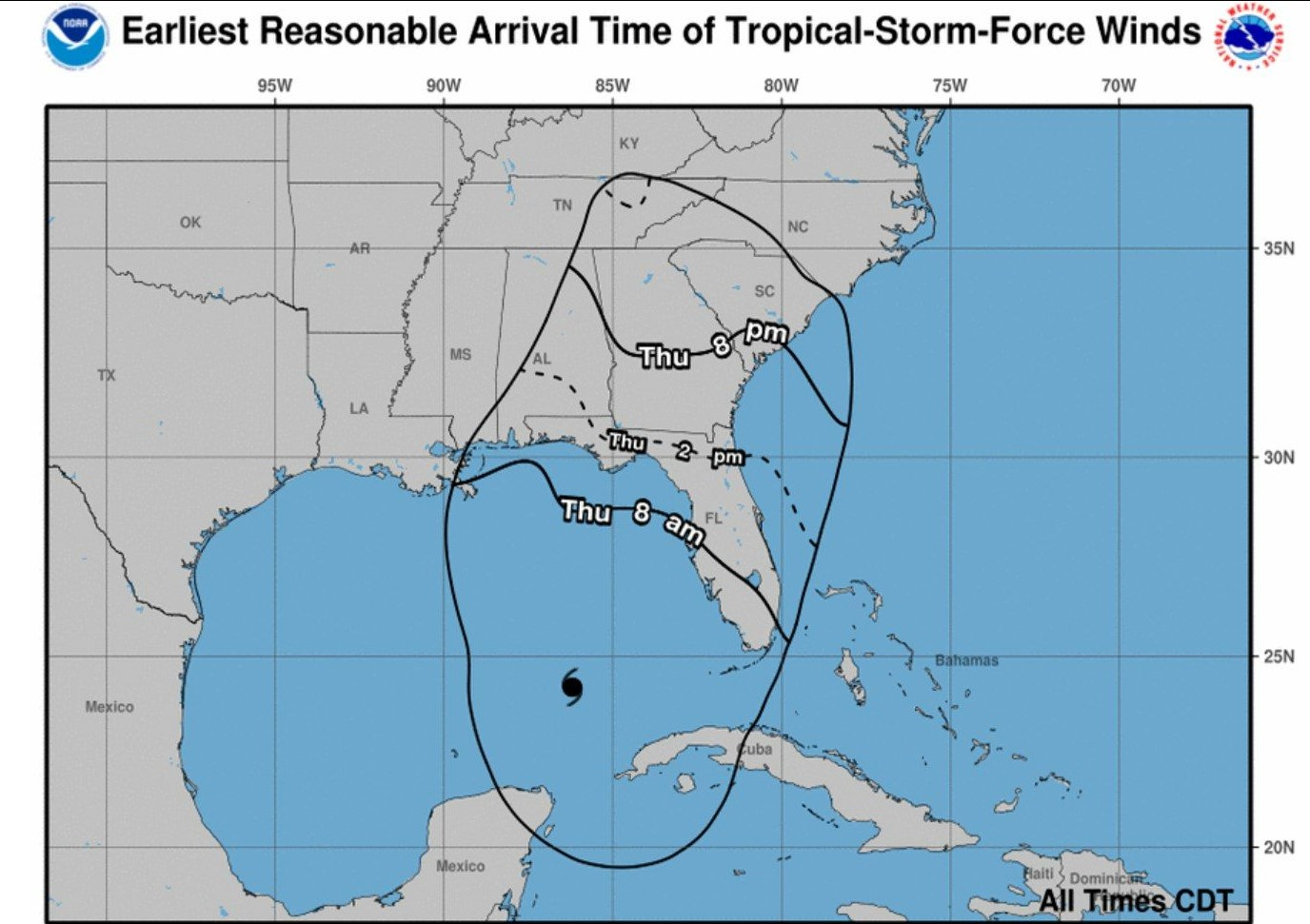
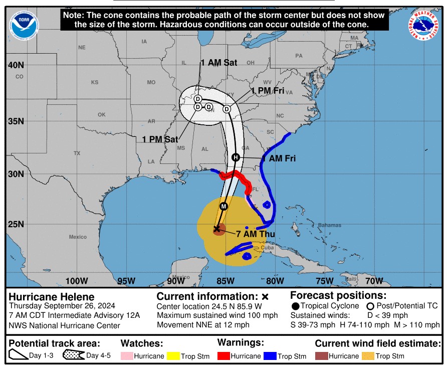 We are currently under a Tropical Storm Watch as Tropical Storm Helene approaches the United States. Helene is expected to strengthen into a major hurricane as it moves across the Gulf of Mexico, making landfall Thursday evening and moving into Georgia overnight into early Friday.
NOW is the time to get prepared for this storm!
Here are some potential impacts:
- 4-6 inches of Rainfall
- Strong winds with gusts above 40 mph
- Possible Tornadoes.
https://www.facebook.com/FortStewartHunterArmyAirfield/videos/2574705806034920
For more tips and up to date information, continue to monitor Fort Stewart and Hunter Army Airfield official social media channels.
Information Source


 https://home.army.mil/stewart/download_file/view/77f48b3a-8617-421f-83f8-4d0eee2dcaee/1118

