
Road Condition Information
FREQUENTLY ASKED QUESTIONS
1. What is the Main Post Fort Wainwright Road Conditions Matrix?
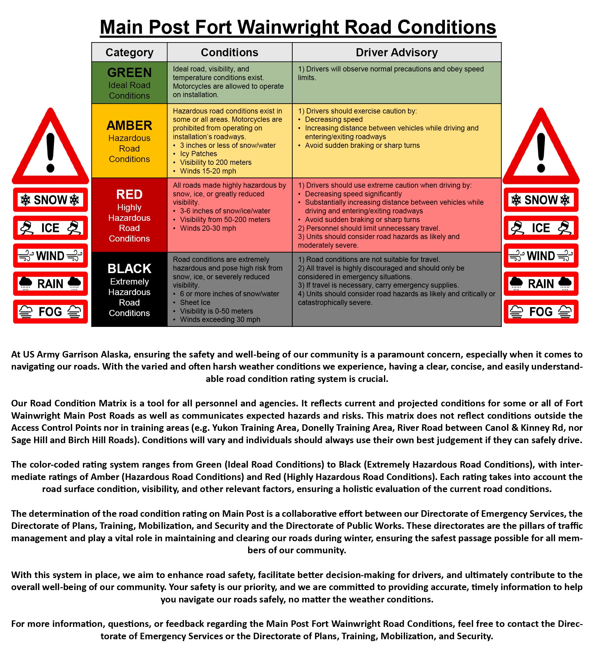
The Main Post Fort Wainwright Road Conditions is a structured, color-coded system designed to provide clear and concise information about the current conditions of roads within Main Post Fort Wainwright. The system uses a scale of Green, Amber, Red, and Black to represent Ideal, Hazardous, Highly Hazardous, and Extremely Hazardous Road Conditions.
2. How is the Road Condition Rating determined?
The rating is determined based on a combination of factors including the road surface condition (dry, wet, snow-packed, icy), visibility, and weather forecasts as well as time of year, effectiveness of clearing operations, and operations on Fort Wainwright. These factors are analyzed by trained personnel in collaboration with weather forecasting agencies to provide an accurate road condition rating.
3. How can I access the current Road Condition Rating?
The current Road Condition Rating can be accessed via the USAG Alaska website, mobile app, or social media. Additionally, real-time updates will be provided through social media platforms and the Digital Garrison app. It is also displayed at all Access Control Points entering Fort Wainwright. Feel free to contact to contact the Directorate of Emergency Services or the Directorate of Plans, Training, Mobilization, and Security.
4. What should I do if the Road Condition Rating is Red or Black?
In Red Road conditions, it is advised to avoid unnecessary travel. When coming to work or if other travel is necessary, drivers should exercise extreme caution by significantly decreasing speed, substantially increasing distance between vehicles while driving and entering/exiting roadways, and avoiding sudden braking or sharp turns. Always carry emergency supplies.
- In Black Road conditions, all travel is highly discouraged and should only be considered in emergency or mission essential situations. If travel is necessary, always carry emergency supplies.
5. What do the different colors in the rating system represent?
- Green: Ideal Road Conditions
- Amber: Hazardous Road Conditions
- Red: Highly Hazardous Road Conditions
- Black: Extremely Hazardous Road Conditions
6. What kind of safety measures should I take during Amber Road conditions?
During Amber rated conditions, drivers should exercise caution by decreasing speed,
increasing distance between vehicles while driving and entering/exiting roadways and avoiding sudden braking or sharp turn.
7. How often is the Road Condition Rating updated?
The Road Condition Rating is updated as often as necessary, especially during changing weather conditions. The goal is to provide the most accurate and up-to-date information to ensure the safety of all road users.
8. Who should I contact for more information about the Road Condition Rating System?
For more information, questions, or feedback regarding the Main Post Fort Wainwright Road Conditions, feel free to contact the Directorate of Emergency Services or the Directorate of Plans, Training, Mobilization, and Security.
9. Can the Road Condition Rating System change during the day?
Yes, the Road Condition Rating can change during the day as weather conditions and road situations evolve. It's crucial to stay updated with the latest road condition ratings especially during adverse weather conditions.
10. Under what Road Condition Rating can I ride my motorcycle?
During spring and summer months (April – September), motorcycles will only be operated on Fort Wainwright when road conditions are Green. During fall and winter months (October - March), motorcycles will only be operated on Fort Wainwright when road conditions are Green, until the first winter snow and/or ice event changes road conditions to Amber, then riding season is closed until road conditions change to Green in a summer month.
11. Are there any educational resources available to understand the Road Condition Rating System better?
Yes, educational materials such as brochures, online tutorials, and community meetings are available to explain the ratings and what actions drivers should take in response to different road conditions. Check the USAG Alaska website or contact the Directorate of Emergency Services or the Directorate of Plans, Training, Mobilization, and Security for more information.
12. What is AK 511?
AK511 provides road condition data outside Main Post from the Alaska Department of Transportation and Public Facilities and partnering agencies. It is a tool that reflects conditions along a segment of road at a specified time.
13. What if we have mission requirements and roads are Red?
Both the Main Post Road Conditions Matrix and AK511 are only tools provided for individuals and units to use to assess risk and make decisions. All units must go through their chain of command for guidance.